3D map by Google
The 3D view is served by Google. Loading it transmits your IP address and technical data about your device to Google.
Your choice applies to this visit. Privacy policy
Surrounding area
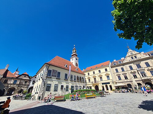
Mödling: old town and the edge of the Vienna Woods
How close is the Vienna Woods when you move to the outskirts?
Twenty minutes by train from Vienna lies a small town with a medieval core, and five minutes past the pedestrian zone the Vienna Woods begin. The walk leads from the station through the old town and on through the rocky gorge of the Mödling stream into the Vorderbrühl.
Getting there: REX1, S2, S3 to Mödling Bahnhof, 15 m to the start. Way back from Vorderbrühl Jägerhausgasse (265, 264), 235 m.
The route and its data
The coloured line is the walk, routed on the real pedestrian network. Toggle a data layer, or tap anywhere on the map to see trees, noise, heat and travel times for that exact spot.
Tap the numbered stops for what makes each spot special, or tap anywhere for the full “what’s here?”.
Every 100 metres of the route, classified from the real data: green spaces, the official noise map, footfall.
About 152 m of climbing and 67 m of descent, between 214 and 337 m above sea level. Sampled every 25 m from open elevation data.
For the city-weary who want to stay connected: a house or period flat with the forest at the door and a frequent S-Bahn. Without a car, everyday life still takes more planning.
Mödling is the outskirts: more quiet, green and space for your money, but without a car you rely on train and bus. The city is about 20 minutes away by S-Bahn.
What changes along the way
Every 100 metres of the walk, sampled against wohnwahn’s data. The bars run from the start (left) to the finish (right). In short: 68% of the way feels green · 84% quiet · a bit off the transit grid.
Values are 0 to 100 per 250 m cell. Parks and water have no residential cell of their own, so those stretches read the nearest neighbourhood. Source: City of Vienna tree register, official urban climate analysis, environmental noise map, footfall and own transit routing.
What’s along the way
Counted within about 140 metres of the route, from our data.
The stops
Homes along this walk
Real listings within about 350 metres of the route.
 20 m from the routeMödlingThe Grand Residences Mödling€ 390,000 · 2 rm · 59.8 m²
 20 m from the routeMödlingThe Grand Residences Mödling€ 2,400,000 · 3 rm · 244.9 m²
 20 m from the routeMödlingThe Grand Residences Mödling€ 1,150,000 · 3 rm · 101.6 m²
 20 m from the routeMödlingThe Grand Residences Mödling€ 449,000 · 2 rm · 59 m²
 20 m from the routeMödlingThe Grand Residences Mödling€ 395,000 · 2 rm · 62.9 m²
 20 m from the routeMödlingThe Grand Residences Mödling€ 580,000 · 2 rm · 80.5 m²
The areas along this walk
The full profile of each area in the atlas: trees, quiet, prices, travel times.

About this walk
How long is the walk?
About 3.3 km, roughly 65 minutes at a normal pace, 4,100–4,700 steps. Routed on the real pedestrian network, not straight-line.
What do the data say about this route?
68% of the way feels green · 84% quiet · a bit off the transit grid. Every figure is measured per 250 m cell and refreshed monthly.
Which neighbourhoods does it cross?
Mödling, Maria Enzersdorf. Each links to its full profile in the neighbourhood atlas.
Walked it? Now find the flat.
Jump into the search along this route, or tap any address on the map to see the data before the viewing.
Search properties here →More on this topic →Explore the atlas →All walks →
Route routed on the OpenStreetMap pedestrian network (© OpenStreetMap contributors, ODbL) · map tiles © CARTO. Data profile: City of Vienna tree register, official urban climate analysis, environmental noise map (BMK), footfall and own transit routing on the Wiener Linien and ÖBB timetables. Data as of 2026-09-04.