Skip to content
DEList a propertyFind a property
Shortlist

Living · Topic

Where can you live by the water in St. Pölten?

You live by the water in Prinzersdorf, Harland and Unterwagram.

“By the water” is a favourite in every listing. wohnwahn measures it instead: 4,467 water features across St. Pölten, from the Traisen to the ponds in the north, and a cooling score per inhabited 250 m cell.

And we say honestly where the trade-offs are: the Traisen is regulated and narrow, and away from its banks there is no water nearby in St. Pölten.

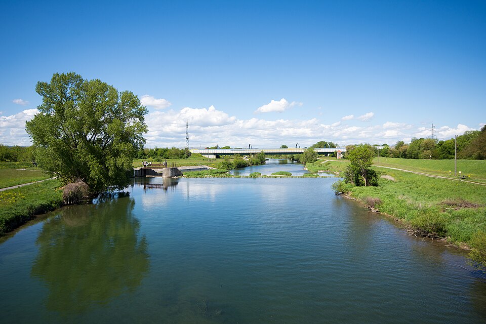
Traisen Harlander Bruecke, St. Pölten
Linie29 · CC BY-SA 4.0

Where St. Pölten lives by the water

Ranked by the share of residential spots near a big open water, so it rewards districts and municipalities with many waterside homes, not a single luxury shoreline. Linked: the full profile in the atlas.

  1. 1Prinzersdorf56 %homes near water
  2. 2Harland42 %homes near water
  3. 3Unterwagram31 %homes near water

Water geometry from OpenStreetMap + a water-cooling score per 250 m cell · as of: October 2026

  1. 4
    St. Georgen am Steinfelde
    water proximity 87/100· Rathausplatz ≈ 21 Min
    30%homes near water
  2. 5
    Stattersdorf
    water proximity 64/100· Rathausplatz ≈ 14 Min
    30%homes near water
  3. 6
    Weinburg
    water proximity 77/100· Rathausplatz ≈ 36 Min· town
    27%homes near water
  4. 7
    Traismauer
    water proximity 75/100· Rathausplatz ≈ 47 Min· town
    26%homes near water
  5. 8
    Oberwagram
    water proximity 64/100· Rathausplatz ≈ 8 Min
    26%homes near water
  6. 9
    Gerersdorf
    water proximity 77/100· Rathausplatz ≈ 14 Min· town
    24%homes near water
  7. 10
    Wilhelmsburg
    water proximity 86/100· Rathausplatz ≈ 29 Min· town
    23%homes near water
  8. 11
    Unterradlberg
    water proximity 61/100· Rathausplatz ≈ 20 Min
    23%homes near water
  9. 12
    Herzogenburg
    water proximity 63/100· Rathausplatz ≈ 38 Min· town
    22%homes near water
  10. 13
    Hafnerbach
    water proximity 81/100· Rathausplatz ≈ 30 Min· town
    21%homes near water
  11. 14
    Viehofen
    water proximity 65/100· Rathausplatz ≈ 16 Min
    19%homes near water
  12. 15
    Spratzern
    water proximity 67/100· Rathausplatz ≈ 15 Min
    18%homes near water
  13. 16
    Ratzersdorf an der Traisen
    water proximity 70/100· Rathausplatz ≈ 13 Min
    17%homes near water
  14. 17
    Ober-Grafendorf
    water proximity 77/100· Rathausplatz ≈ 23 Min· town
    16%homes near water
  15. 18
    Neu-Hart
    water proximity 47/100· Rathausplatz ≈ 18 Min
    10%homes near water
  16. 19
    Zentrum
    water proximity 63/100· Rathausplatz ≈ 11 Min
    9%homes near water
  17. 20
    Pottenbrunn
    water proximity 58/100· Rathausplatz ≈ 16 Min
    8%homes near water
  18. 21
    Nußdorf ob der Traisen
    water proximity 47/100· Rathausplatz ≈ 53 Min· town
    3%homes near water

Method: proximity to the big open waters per inhabited 250 m cell (the Traisen, the Mühlbach and the bathing ponds in the north count), bigger and closer water weighs more, share of cells above the threshold, clipped to the real boundary. Channelled races and small brooks are deliberately excluded, they don’t make a waterside home. A district scores high when many homes sit near water, not because of one exclusive shore.

Homes near the water

Currently 21 listings sit on wohnwahn by the water, closest first. Each card says how close.

2 listingsSee all listings in St. Pölten →

Reset filters

The water map of St. Pölten

Deeper blue means closer to open water. Every square is an inhabited 250 m cell; the Traisen, the Mühlbach and the bathing ponds in the north count, culverted ditches and small brooks do not.

dryat the water

Only inhabited cells are coloured. This is a proximity model for the big open waters, NOT an official flood map. Tap the map for the water-proximity score at that exact spot.

By the water and still central

Water usually means the edge of the city. These places prove otherwise: many waterside homes AND within 20 minutes of Rathausplatz by transit (the Traisen in Wagram is the classic).

What to check for a real waterside flat

The water view is the flat’s job, not the location’s

Our data shows how close and how cooling the water is around an address. Whether you actually see it depends on the floor, the orientation and the building, that’s what the listing and a viewing tell you.

The Traisen is not a bathing pond

The Traisen is a regulated river with a cycle path, good for walking and for the cooler air. The ponds in the north are for swimming, but they are further from the centre and crowded in summer.

The number is small, and that is the answer

Only a handful of areas score above zero at all. We show those instead of claiming a difference that does not exist: if you want water, look at these few strips, and for everywhere else this topic simply does not apply.

St. Pölten is not a city on the water

That is the most honest sentence on this page. In most parts of this market the score is zero, because there simply is no larger body of water nearby. Here a waterside location is the exception, not the feature you sort the city by.

Frequently asked questions

Where in St. Pölten can you live right by the water?

By share of waterside homes it is Prinzersdorf (56% of residential spots near water), followed by Harland and Unterwagram. The waterside locations are along the Traisen and at the ponds in the north: Wagram, Viehofen and Harland. Source: OpenStreetMap water geometry, evaluated per 250 m cell.

Is living by the water a flood risk?

wohnwahn measures water proximity and cooling, not flood risk. The Traisen is regulated; anyone planning to live beside it should check the official hazard zone plan of Lower Austria.

The Traisen or the ponds in the north, what is the difference?

The Traisen runs through the city: cycle path, cooler air, central. The ponds in the north are for swimming, but they lie outside town and get busy on hot weekends.

Where do you live by the water AND close to the centre?

Unterwagram for example: many waterside homes and still ≈ 8 minutes from Rathausplatz by transit. Wagram is the textbook case: the Traisen and the cycle path at your door, the centre eight minutes away.

How current is the water data?

Water geometry from OpenStreetMap, cooling score per inhabited 250 m cell, refreshed monthly (as of October 2026).

More honest data on where to live well in St. Pölten and the surrounding area.

This topic inViennaGrazSalzburgLinzInnsbruckBregenzKlagenfurtEisenstadt

Find a home by the water, honestly.

Search, tap any address on the map, and see the water, the cooling, the noise and the travel times before the viewing. Free and independent.

Search homes →

Sources: water geometry OpenStreetMap · cooling effect: own model per 250 m cell · transit: own routing on the LUP St. Pölten and ÖBB timetables. Not an official flood map. Refreshed monthly.