Skip to content
DEList a propertyFind a property
Shortlist

Living · Topic

Where can you live by the water in Innsbruck?

You live by the water in Mariahilf - St. Nikolaus, Dreiheiligen - Schlachthof and Saggen.

“By the water” is a favourite in every listing. wohnwahn measures it instead: 2,596 water features across Innsbruck, from the Inn to the Sill, and a cooling score per inhabited 250 m cell.

And we say honestly where the trade-offs are: traffic on the embankment roads, a cold river rather than a bathing spot, and on the slopes the water is far away.

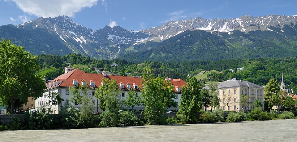
Innsbruck Innufer2
Taxiarchos228 · FAL

Where Innsbruck lives by the water

Ranked by the share of residential spots near a big open water, so it rewards districts with many waterside homes, not a single luxury shoreline. Linked: the full profile in the atlas.

  1. 1Mariahilf - St. Nikolaus100 %homes near water
  2. 2Dreiheiligen - Schlachthof100 %homes near water
  3. 3Saggen100 %homes near water

Water geometry from OpenStreetMap + a water-cooling score per 250 m cell · as of: September 2026

  1. 4
    Olympisches Dorf
    water proximity 90/100· Maria-Theresien-Straße ≈ 22 Min
    100%homes near water
  2. 5
    Innenstadt
    water proximity 78/100· Maria-Theresien-Straße ≈ 5 Min
    90%homes near water
  3. 6
    Gewerbegebiet Roßau
    water proximity 78/100· Maria-Theresien-Straße ≈ 23 Min
    71%homes near water
  4. 7
    Gewerbegebiet Mühlau / Arzl
    water proximity 84/100· Maria-Theresien-Straße ≈ 18 Min
    69%homes near water
  5. 8
    Höttinger Au
    water proximity 83/100· Maria-Theresien-Straße ≈ 15 Min
    64%homes near water
  6. 9
    Schönberg im Stubaital
    water proximity 83/100· Maria-Theresien-Straße ≈ 29 Min· town
    62%homes near water
  7. 10
    Reichenau
    water proximity 94/100· Maria-Theresien-Straße ≈ 17 Min
    60%homes near water
  8. 11
    Sieglanger - Mentlberg
    water proximity 81/100· Maria-Theresien-Straße ≈ 15 Min
    59%homes near water
  9. 12
    Wilten
    water proximity 86/100· Maria-Theresien-Straße ≈ 14 Min
    58%homes near water
  10. 13
    Vill
    water proximity 69/100· Maria-Theresien-Straße ≈ 28 Min
    56%homes near water
  11. 14
    Pradl
    water proximity 80/100· Maria-Theresien-Straße ≈ 13 Min
    49%homes near water
  12. 15
    Ampass
    water proximity 84/100· Maria-Theresien-Straße ≈ 34 Min· town
    47%homes near water
  13. 16
    Mühlau
    water proximity 85/100· Maria-Theresien-Straße ≈ 17 Min
    46%homes near water
  14. 17
    Hall in Tirol
    water proximity 82/100· Maria-Theresien-Straße ≈ 28 Min· town
    45%homes near water
  15. 18
    Patsch
    water proximity 77/100· Maria-Theresien-Straße ≈ 38 Min· town
    42%homes near water
  16. 19
    Zirl
    water proximity 85/100· Maria-Theresien-Straße ≈ 32 Min· town
    41%homes near water
  17. 20
    Völs
    water proximity 77/100· Maria-Theresien-Straße ≈ 20 Min· town
    36%homes near water
  18. 21
    Hötting
    water proximity 70/100· Maria-Theresien-Straße ≈ 13 Min
    34%homes near water
  19. 22
    Unterperfuss
    water proximity 75/100· Maria-Theresien-Straße ≈ 29 Min· town
    30%homes near water
  20. 23
    Mils
    water proximity 81/100· Maria-Theresien-Straße ≈ 38 Min· town
    28%homes near water
  21. 24
    Mutters
    water proximity 74/100· Maria-Theresien-Straße ≈ 44 Min· town
    18%homes near water
  22. 25
    Kematen in Tirol
    water proximity 64/100· Maria-Theresien-Straße ≈ 28 Min· town
    14%homes near water
  23. 26
    Hötting West
    water proximity 73/100· Maria-Theresien-Straße ≈ 19 Min
    13%homes near water
  24. 27
    Tulfes
    water proximity 86/100· Maria-Theresien-Straße ≈ 35 Min· town
    13%homes near water
  25. 28
    Natters
    water proximity 79/100· Maria-Theresien-Straße ≈ 28 Min· town
    10%homes near water
  26. 29
    Ellbögen
    water proximity 60/100· Maria-Theresien-Straße ≈ 45 Min· town
    9%homes near water
  27. 30
    Rum
    water proximity 63/100· Maria-Theresien-Straße ≈ 24 Min· town
    9%homes near water
  28. 31
    Thaur
    water proximity 57/100· Maria-Theresien-Straße ≈ 29 Min· town
    5%homes near water
  29. 32
    Arzl
    water proximity 65/100· Maria-Theresien-Straße ≈ 24 Min
    5%homes near water
  30. 33
    Amras
    water proximity 41/100· Maria-Theresien-Straße ≈ 18 Min
    2%homes near water

Method: proximity to the big open waters per inhabited 250 m cell (the Inn, the Sill and the bathing lakes around the city count), bigger and closer water weighs more, share of cells above the threshold, clipped to the real boundary. Channelled races and small brooks are deliberately excluded, they don’t make a waterside home. A district scores high when many homes sit near water, not because of one exclusive shore.

Homes near the water

Currently 1 listing sits on wohnwahn by the water, closest first. Each card says how close.

1 listingSee all listings in Innsbruck →

Reset filters

The water map of Innsbruck

Deeper blue means closer to open water. Every square is an inhabited 250 m cell; the Inn, the Sill and the bathing lakes around the city count, culverted brooks and snowmaking ponds up on the mountain do not.

dryat the water

Only inhabited cells are coloured. This is a proximity model for the big open waters, NOT an official flood map. Tap the map for the water-proximity score at that exact spot.

By the water and still central

Water usually means the edge of the city. These places prove otherwise: many waterside homes AND within 20 minutes of Maria-Theresien-Straße by transit (the Inn promenade in Mariahilf and St. Nikolaus is the classic).

What to check for a real waterside flat

The water view is the flat’s job, not the location’s

Our data shows how close and how cooling the water is around an address. Whether you actually see it depends on the floor, the orientation and the building, that’s what the listing and a viewing tell you.

One bank of the Inn is not the other

On the north bank in Mariahilf and St. Nikolaus the promenade runs in front of the houses, car-free and sunny. The south bank carries Innrain and Innstraße, a main axis: the same view, with the traffic in between.

The Sill is the little brother

The Sill is narrow, partly walled in and flanked by the railway and the motorway. It counts as a waterside location, but it feels different from the Inn, and in Dreiheiligen the noise of the valley axis comes with it.

The Inn is not a river to swim in

The Inn carries glacier water: cold, fast and largely between levees. “On the Inn” means a view and cooler air, not swimming, and on the south bank it often means Innrain or Innstraße with the traffic in between. Read the map, not the listing.

Frequently asked questions

Where in Innsbruck can you live right by the water?

By share of waterside homes it is Mariahilf - St. Nikolaus (100% of residential spots near water), followed by Dreiheiligen - Schlachthof and Saggen. The classic addresses are on the Inn: Mariahilf and St. Nikolaus on the north bank, Saggen to the east, plus the Olympic Village and the Sill in Dreiheiligen. Source: OpenStreetMap water geometry, evaluated per 250 m cell.

Is living by the water a flood risk?

wohnwahn measures water proximity and cooling, not flood risk. The Inn runs between levees for long stretches, and the official hazard zones of the Province of Tyrol have their own tool here.

Inn or Sill, what is the difference?

The Inn is the broad river with a promenade, a view of the Nordkette and the old town within walking distance. The Sill is a narrow, partly channelled stream in a louder corridor: closer to rail and motorway, but cheaper.

Where do you live by the water AND close to the centre?

Mariahilf - St. Nikolaus for example: many waterside homes and still ≈ 5 minutes from Maria-Theresien-Straße by transit. St. Nikolaus is the textbook case: the Inn at your door, the old town five minutes away across the bridge.

How current is the water data?

Water geometry from OpenStreetMap, cooling score per inhabited 250 m cell, refreshed monthly (as of September 2026).

More honest data on where to live well in Innsbruck and the surrounding area.

This topic inViennaGrazSalzburgLinzSt. PöltenBregenzKlagenfurtEisenstadt

WaterOn footBoth banks of the Inn: the coloured houses and the cold waterA glacier river through the middle of town, and two banks that could hardly differ more.

Find a home by the water, honestly.

Search, tap any address on the map, and see the water, the cooling, the noise and the travel times before the viewing. Free and independent.

Search homes →

Sources: water geometry OpenStreetMap · cooling effect: own model per 250 m cell · transit: own routing on the IVB and ÖBB timetables. Not an official flood map. Refreshed monthly.